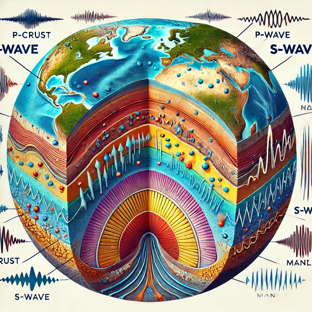
Seismology is the scientific study of seismic waves generated by earthquakes, which propagate through the Earth’s interior. The cross-sectional diagram illustrates the propagation of two primary types of seismic waves—P-waves (Primary waves) and S-waves (Secondary waves)—emanating from an earthquake's epicenter. P-waves are compressional waves that travel fastest and can move through both solid and liquid layers of the Earth. In contrast, S-waves are shear waves that travel slower and can only move through solid materials. The diagram shows how these waves interact with different layers of the Earth, including the crust, mantle, and core, providing valuable insights into the Earth's internal structure. By analyzing the speed, direction, and behavior of these waves, seismologists can infer properties like the composition, density, and state of matter within the Earth.
Geomagnetism
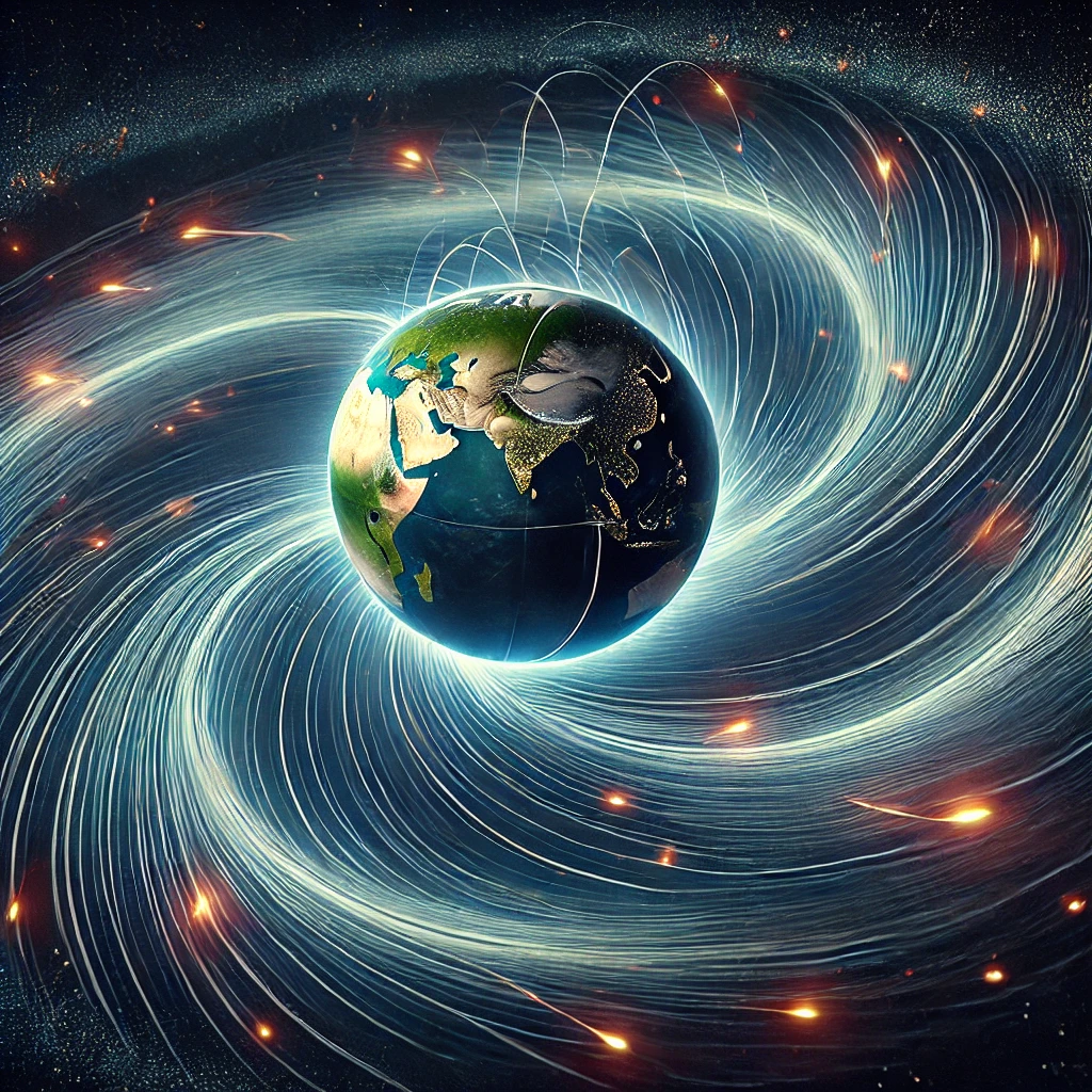
Geomagnetism involves the study of Earth's magnetic field, which extends from the planet's interior out into space, where it interacts with solar wind. The diagram represents Earth’s magnetic field, showing field lines that extend from the magnetic poles and loop around the planet. This magnetic field is generated by the movement of molten iron within Earth’s outer core and is vital for protecting the planet from harmful solar radiation. The magnetosphere, formed by the interaction between the magnetic field and solar wind, acts as a shield, deflecting charged particles and protecting the atmosphere from solar wind erosion. This protective barrier is crucial for maintaining the conditions necessary for life on Earth, as it prevents the solar wind from stripping away the ozone layer, which protects the planet from harmful ultraviolet radiation.
Gravimetry
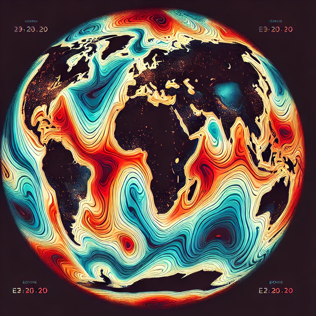
Gravimetry is the measurement and study of variations in Earth's gravitational field, which reflect differences in the distribution of mass within the planet. The global map of gravity anomalies shows areas where gravitational strength deviates from the standard geoid—a theoretical surface of equal gravitational potential. Regions with positive gravity anomalies (indicated by warmer colors) suggest areas of higher mass density, such as mountain ranges or dense rock formations. In contrast, negative anomalies (indicated by cooler colors) may indicate regions with lower mass density, such as deep ocean trenches or sedimentary basins. These variations in gravitational strength provide critical information about the Earth's subsurface structures, contributing to our understanding of geological processes such as tectonic activity, volcanic formation, and sediment deposition.
Geo dynamics : Plate Tectonics and Crustal Deformation
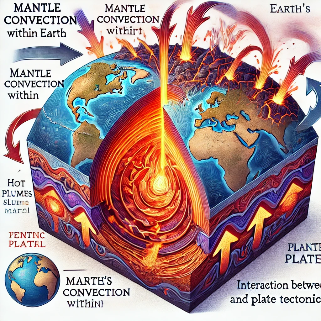
Geodynamics explores the forces and processes that drive the movement of Earth's lithosphere. The diagram of mantle convection illustrates how heat from the Earth’s core causes the movement of molten material within the mantle, creating convection currents. These currents drive the movement of tectonic plates at the Earth’s surface. Hot, buoyant material rises from the deeper mantle towards the surface, where it cools and spreads out, causing the overlying plates to move apart. Simultaneously, cooler, denser material sinks back into the mantle at subduction zones, pulling tectonic plates along with it. This continuous cycle of rising and sinking material is the engine behind plate tectonics, leading to the formation of mountains, earthquakes, and volcanic activity. Understanding mantle convection is essential for explaining the dynamic nature of Earth's surface and the long-term evolution of the planet.
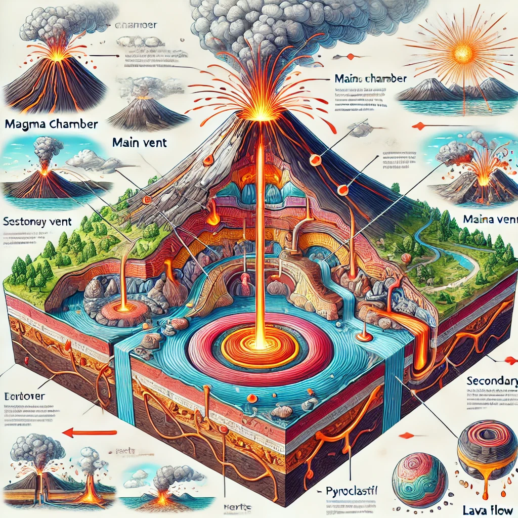
Volcanology: Understanding Volcanic Activity
Volcanology is the study of volcanoes, volcanic processes, and the related phenomena associated with the movement of molten rock, or magma, from beneath the Earth's crust to the surface. The cross-sectional diagram of a volcano provides a detailed look into the internal and external structure of a typical stratovolcano, showcasing key features such as the magma chamber, main vent, secondary vents, and crater.
The magma chamber, located deep within the Earth, is the source of molten rock that feeds volcanic eruptions. Magma rises through the main vent, a conduit connecting the magma chamber to the Earth's surface. During an eruption, magma reaches the surface, where it is expelled as lava through the crater, the opening at the top of the volcano. Secondary vents may also form along the sides of the volcano, allowing lava and gases to escape in different locations.
The diagram also illustrates other significant volcanic features, such as ash clouds, pyroclastic flows, and the accumulation of solidified lava and ash layers that build up the volcano over time. Ash clouds, composed of fine volcanic particles, are ejected into the atmosphere and can travel vast distances, affecting climate and air travel. Pyroclastic flows, fast-moving currents of hot gas and volcanic material, pose severe hazards to nearby life and property.
Volcanic activity is driven by the movement of tectonic plates and the heat from the Earth's interior. Understanding these processes is critical for assessing volcanic hazards, predicting eruptions, and mitigating their impacts on human populations and infrastructure. The study of volcanology not only helps in disaster preparedness but also provides insights into the Earth's geological history and the dynamic processes shaping our planet.